I purchased the excellent Garmin 441s chartplotter in the spring of 2011. So far, I really like it. I would not claim to have fully utilized it or played with every feature – there are many!
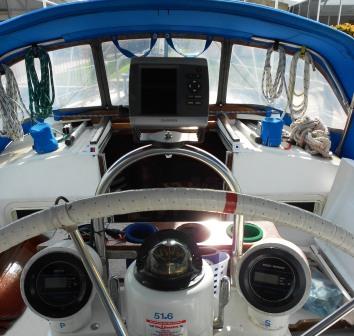
I agonized over where to mount it. I have seen a lot of installations with the unit inside the cabin on a swing out mount so it can be viewed from the cabin but I really wanted it more visible and available when at the helm. I have it mounted on here my pedestal.
Why the “s” model Garmin 441 gps chartplotter? I spent a lot of time researching the various models and options. The Garmin 441s comes with coastal/Bahamas maps installed, NMEA 0183 and 2000 input/output, AIS tracking (with a separate AIS receiver), XM Weather option, and the ability to add a transducer for depth/fish finder, speed, and temperature data. You have to be very careful with your selection as there are a lot of options and variables. For example, the Garmin 431 is very similar but comes with inland waterway maps instead of coastal maps.
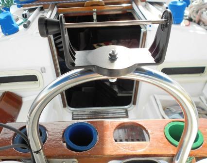
My mount is crude. It works well but I doubt that it is the final form. It is basically just a hole thru the pedestal tubing. The real down side that I have noted is the temptation to grab the unit as a hand hold when things get rough. The unit is easy remove and I store it in the cabin when not in use. I may try mounting it under the pedestal tube (on the cub holder seen in the following photo) at some point.
Like most Garmin products, the user interface is intuitive and friendly. The charts/maps that come with the unit have been quite good for the areas that I have been to (Gulf coast of Florida). The G2 Vision charts provide more detail and satelite imagery but cost extra, I did not purchase them.
Similar to automotive and aviation, the use of a GPS receiver and moving map software makes sailing navigation simple. Obviously, paper charts and track of our position is important as there is no guarantee of GPS signal. For those that don’t know, the concept on which GPS works is quite amazing. A GPS unit is only a receiver, it does not transmit anything. The satellites (24 of them) in a 12,000 mile orbit have extremely accurate clocks and are transmitting a small bit of data. The GPS receives this data and triangulates the position of the receiver based on the very small differences in time between when the packets of data were sent by the satellites and when they were received by the receiver. Obviously, these are very small periods of time.


Leave a Reply